The Bay at the centre of Boon Wurrung, Wurundjeri and Wathaurung Country is called Narrm Narrm or Nairm.
It was called Port Phillip Bay by colonisers. Kulin people have a deep knowledge of the Bay developed over many generations, including of its waters, tides, coast and its fish and animals. Western science is slowly starting to catch up with this Kulin knowledge, including about how the Bay was formed.
The Great Flood
Boon Wurrung and Wurundjeri people each have stories about a great flood that caused the Bay to form very quickly. Before this flood occurred, the area where the Bay is now was a dry, grassy plain that was a good hunting ground for emu and kangaroo. The Birrarung (Yarra River) flowed across this plain to the sea.
You can read the Boon Wurrung story as told by Aunty Carolyn Briggs at the Culture Victoria website - Boon Wurrung: The Filling of the Bay – The Time of Chaos.
You can read full Wurundjeri story at the Museums Victoria page – Life in the Victorian Forest, How the Yarra was formed (scroll down to view story).
Boon Wurrung and Wurundjeri people have many different stories about how their Country, including the Bay, was formed. These stories contain complex layers of knowledge and share information about morality (how you should act and follow Lore), spirituality (including connection to Creators such as Bunjil the Eagle) and science.
Western science plays catch up
Since invasion, colonisers have repeatedly dismissed the scientific knowledge of Aboriginal people. Western scientists for years held the view that the Bay had remained unchanged for 10,000 years. However, recent studies have proved this view to be incorrect.
In 2011, a Melbourne University study by Dr. Guy Holdgate showed that 1000 years ago, the Bay was dry land and the Birrarung (Yarra River) and Werribee Rivers ran through it. The study found that the entrance to the Bay was blocked by sand and silt build up, cutting it off from the Bass Strait. The water in the Bay evaporated and was dry, except for a small salty lake in the middle where the rivers ended. The channels made by the rivers can still be found on the sea floor of the Bay. Because the Bay was lower than sea level, when the sand bar blocking the sea was breached less than 1000 years ago, possibly by an earthquake, storms or erosion, it filled very quickly as is told in the stories.

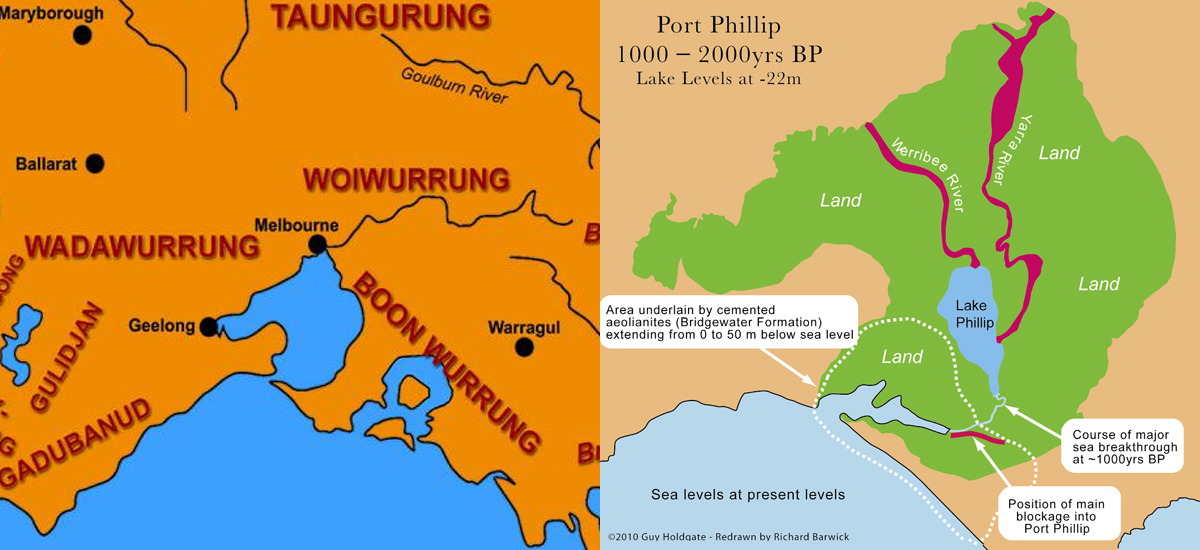
Comparison map showing the Bay before and after The Great Flood. Aboriginal Language Map sourced from VACL.
Sources & Further Reading
- Culture Victoria, Aunty Caroline Briggs, Boon Wurrung: The Filling of the Bay – The Time of Chaos
- Museums Victoria, Life in the Victorian Forest, How the Yarra was formed
- The Age, Stephen Cauchi, 10,000-year bay theory doesn't hold water
- ABC Science, Port Phillip Bay once high and dry
- State of Victoria, Aboriginal Country